
Related
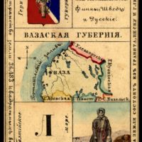
Vasa Province, Russian empire, 1856 - Public domain map
Kutaisi Province, Russian empire, 1856
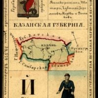
Kazan Province, Russian empire - Public domain old map
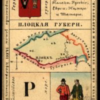
Plotsk Province, Russian empire, 1856

Kaunas (Kovno) Province, Russian empire, 1856
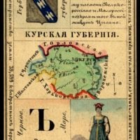
Kursk Province, Russian empire, 1856

The land of Chukotka and the Kamchatka region, Russian empire, 1856

Kamenets-Podolsk Province, Russian empire, 1856
Kazan Province, Russian empire, 1856
Kanina Land. Boat., Russian Empire, 19th century
Summary
Murmansk shore, Murman. The Pomeranian coast is the shore of the Barents Sea from the Norwegian border to Cape St. Nose. Has several deep-cutting bays (Kola, Motovsky, and others), along the coast - a number of islands (the largest - Kildin). The most important port is Murmansk. Мурманский берег, Мурман. Поморский берег — берег Баренцева моря от Норвежской границы до мыса Святой Нос. Имеет несколько глубоко врезающихся заливов (Кольский, Мотовский и другие), вдоль берега — ряд островов (наиболее крупный — Кильдин). Важнейший порт — Мурманск.
Murmansk shore, Murman. The Pomeranian coast is the shore of the Barents Sea from the Norwegian border to Cape St. Nose. Has several deep-cutting bays (Kola, Motovsky, and others), along the coast - a number of islands (the largest - Kildin). The most important port is Murmansk. Мурманский берег, Мурман. Поморский берег — берег Баренцева моря от Норвежской границы до мыса Святой Нос. Имеет несколько глубоко врезающихся заливов (Кольский, Мотовский и другие), вдоль берега — ряд островов (наиболее крупный — Кильдин). Важнейший порт — Мурманск
Nothing Found.