Murmansk shore, Murman. The Pomeranian coast is the shore of the Barents Sea from the Norwegian border to Cape St. Nose. Has several deep-cutting bays (Kola, Motovsky, and others), along the coast - a number of More
Samoyeds (also "Samoyed", "self-united") were first called only the Nenets - the largest Samoyed people, but later this name was also used as a collective name for all Samoyedic peoples. Самоедами (также «само More
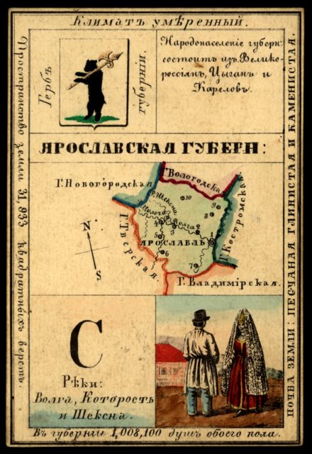
Yaroslavl Province This card is one of a souvenir set of 82 illustrated cards–one for each province of the Russian Empire as it existed in 1856. Each card presents an overview of a particular province’s cultur More
Astrakhan Province This card is one of a souvenir set of 82 illustrated cards–one for each province of the Russian Empire as it existed in 1856. Each card presents an overview of a particular province’s cultur More
This card is one of a souvenir set of 82 illustrated cards–one for each province of the Russian Empire as it existed in 1856. Each card presents an overview of a particular province’s culture, history, economy, More
Samara Province This card is one of a souvenir set of 82 illustrated cards–one for each province of the Russian Empire as it existed in 1856. Each card presents an overview of a particular province’s culture, More
Карта Смоленского уезда. — 1: 840 000 Планы городов и карты уездов Смоленской губернии конца XVIII века. Plans of cities and maps of districts of Smolensk province at the end of the XVIII century
План области города Красный. — 1: 13 776 Планы городов и карты уездов Смоленской губернии конца XVIII века. Plans of cities and maps of districts of Smolensk province at the end of the XVIII century
План Рославльского уезда. Планы городов и карты уездов Смоленской губернии конца XVIII века Plans of cities and maps of districts of Smolensk province at the end of the XVIII century
План уезда города Ельня. Планы городов и карты уездов Смоленской губернии конца XVIII века Plans of cities and maps of districts of Smolensk province at the end of the XVIII century
Гжатский уезд. Планы городов и карты уездов Смоленской губернии конца XVIII века Plans of cities and maps of districts of Smolensk province at the end of the XVIII century
Планы городов и карты уездов Смоленской губернии конца XVIII века Plans of cities and maps of districts of Smolensk province at the end of the XVIII century
Духовщина. Планы городов и карты уездов Смоленской губернии конца XVIII века Plans of cities and maps of districts of Smolensk province at the end of the XVIII century
План Дорогобужского уезда. Планы городов и карты уездов Смоленской губернии конца XVIII века Plans of cities and maps of districts of Smolensk province at the end of the XVIII century
Карта Смоленской губении. Описание рек протекающих в Смоленской губернии. Планы городов и карты уездов Смоленской губернии конца XVIII века Plans of cities and maps of districts of Smolensk province at the en More