
Related

Land of Kanina shore. Postcards.

Kanina Land Shore Erosion.., Russian Empire, 19th century

Kanina Land - Summer. Postcards.

Kanina Land - Temporary fishermen dwelling. Postcards.

Post card. Baku., Russian Empire, 19th century

Flood of the Klyazma., Russian Empire, 19th century

Kanina Land. Boat., Russian Empire, 19th century

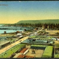
Baku, customs pier. Post card., Russian Empire, 19th century
Baku. Bibi Heybat. Post card., Russian Empire, 19th century
Kanina Land shore erosion. Postcards.
Summary
Murmansk shore, Murman. The Pomeranian coast is the shore of the Barents Sea from the Norwegian border to Cape St. Nose. Has several deep-cutting bays (Kola, Motovsky, and others), along the coast - a number of islands (the largest - Kildin). The most important port is Murmansk. Мурманский берег, Мурман. Поморский берег — берег Баренцева моря от Норвежской границы до мыса Святой Нос. Имеет несколько глубоко врезающихся заливов (Кольский, Мотовский и другие), вдоль берега — ряд островов (наиболее крупный — Кильдин). Важнейший порт — Мурманск.
Murmansk shore, Murman. The Pomeranian coast is the shore of the Barents Sea from the Norwegian border to Cape St. Nose. Has several deep-cutting bays (Kola, Motovsky, and others), along the coast - a number of islands (the largest - Kildin). The most important port is Murmansk. Мурманский берег, Мурман. Поморский берег — берег Баренцева моря от Норвежской границы до мыса Святой Нос. Имеет несколько глубоко врезающихся заливов (Кольский, Мотовский и другие), вдоль берега — ряд островов (наиболее крупный — Кильдин). Важнейший порт — Мурманск
Nothing Found.